Saturday, March 18, 2006


We Have Started The 10 Step Program

Preparation for D-Day. Can you believe we have started the 10 step program! They say if you write it down it will become a reality. So, I am writing it down for all to see. I know there are the ney-sayers that have listen, nodding their heads with a big smile on their faces as we spoke of our dreams and ambitions. This has been so far a 10 year venture. Traveling North America looking for boats, taking numerous boating related classes, learning as much as we can about the trip we plan. Aligning ourselves with groups that can help with our conquests. These next two years will be action pact. We hope to depart August/September / 2008. It will be here before we know it!

Step 1
Clean out the house!
The main words that go through my mind are PURGE, PURGE, PURGE.! Thirty years worth. What a job it has been. Those to benefit so far seem to be the Salvation Army. We will be having a garage sale soon. The rule is --- If it doesn’t fit on the boat it doesn’t get kept. I just have to persuade a relative, friend to take a few things, like pictures, family bible. A box load. Names that come to mind….. Pam, Janet! I haven’t asked yet!

Step 2
Renovate the house!
The renovations are underway as this is being written. It should be done in a month. We are doing way more than originally planned. Rooms are getting new hardwood, 2 new furnaces, new bathroom for the main, new, new, new. And above all BASEBOARD! For some you know what that means. The housing market is hot and we want to get in on it.
We are having a work weekend in May to get the outside finished. Weather permitting. I bet all those friends living outside of Calgary are sighing a sigh of relief! Goal to be ready by June 1/06

Step 3
Sale the house!

Step 4
Talk to our financial planner!

Step 5
Make sure Alanna and RJ are set up ok!

Step 6
Retirement Day!

Step 7
Move to the boat!

Step 8
Finish boat renovations

Step 9
Prepare for departure

Step 10
Bon Voyage!

Friday, March 10, 2006


We were up bright and early to reach Surge Narrows (Beazley Passage) to navigate at near slack water. Currents build from dead calm to speeds of up to 13 knots within 3 hours, generating heavy tidal overfalls. There is only a 15 minute grace period to get through at slack water.

We stayed for 2 days celebrating our 23rd wedding anniversary at Octopus Islands.
Octopus Island Provincial Park is located between Quadra Island and Maurelle Island in Okisollo Channel. It is both remote and accessible at the same time. Nestled among a group of islands through which the waters of Johntsone Strait funnel into the Strait of Georgia. The area is undeveloped and pristine. We dropped the crab traps and had a bountiful of crab.

Hole in the Wall just outside the marine park is a mecca for fishermen that use the back eddies to catch the churning fish. To travel though these currents it must be done at slack There is only a 10 minute period where one can travel through. Hole in the Wall has strong turbulence and eddies along the north side of the west entrance.

As we continued our journey we decided to go up Johnstone Strait to Blind Channel (West Thurlow Island). The Blind Bay Marina would be our destination. It is a popular cruising stop and during the summer season would be extremely crowded, in fact a reservation would be necessary. The second week in September found half a dozen boats. We choose this place as there are forest trails to help stretch those legs out.
Ken and I decided to take the hike. Liz and Richard would stay at the boat as Liz was not certain that the hike would be good for her knee. We befriended a dog at the end of the warf. We called him Rex. We kept trying to send him home but he would have no part of it. As he led the way we came to a sign that read "Beware of Cougars, and Bears. We no longer tried to send Rex back in fact we were more than pleased to let Rex lead the way.

The Big Cedar Trail (45 min) leads across a creek and up through an old growth cedar rain forest. An 800 year old cedar tree, 24 feet in diameter, resides at the end of the trail. This forest has been harvested 3 times since 1872. It was quite remarkable and fortunately we saw no wildlife other than Rex.

Off to our next destination. Granite Bay on Quadra Island. Granite Bay is a landlocked bay , offering excellent protection in all weather. We had come to the Canadian Version of The Ozarks. We had the rickety old shacks, the characters that had to make us grin. Were we in OZ? Strange but oh so beautiful. Life traveling at a snails pace but everyone content to be in this place. Magic mushrooms? BC home grown marijuana? Two of the characters, two sheets to the wind( a nautical term) were collecting jellyfish for research for the government. Getting paid $1.00 a jellyfish. I am not so certain they were telling the truth.

The following day Liz and I were to catch a flight out of Campbell River having completed a ten day vacation with nothing but sun, great fishing and great company. Ken and Richard would continue on for the next four days putting the boat back into its slip until the next adventure.

Tuesday, March 07, 2006


Here Ken is standing on the logboom we affixed ourselves. They are sitting in water approximately in 90' deep.


We hiked up the falls to Cassel Lake. A clear warm lake just above the falls.


Sunset pictures are always
something we try to capture. This sunset was taken while we were anchored at The Gorge on Cortes Island. The sky was a glow of purples. It was awesome. The next day was a beautiful day so the saying "Red Sky at Night" must apply to purple skies also.

This sunset was taken at octopus Island Marine Park on Quadra island.

The second night at Octopus Island.

Sunsets and sunrises are always interesting. We haven't been able to catch sunrises worth printing. Yet! This is caused mostly to the fact the sunrises seem to be blocked by mountains quite often. (Not that we are still in bed!).

Monday, March 06, 2006

In general, September has been a great month to go cruising, with the exception of 2004. This September would give us the finest weather to date.

Liz and Richard would be our crew for the next two weeks. Ken and Richard teach boating classes together. Richard had a vessel of his own at one time but currently has become land locked. We were looking forward to venturing out with Richard’s local knowledge. I had been in Richard’s boating classes over the years and had heard about his escapades. Was I ready to possibly become involved in one!

Pender Harbour would be our first port of call. The Pender Harbour area was once the winter capital of the Coast Salish nation, specifically the Shishalh tribe, from which the town of Sechelt takes its name. Judging by the wealth of archaeological evidence, the local population in 1800 was greater than it is now. The Shishalh people were highly industrious during the summer months, fishing for salmon, hunting venison and gathering berries, all of which were dried for winter use. They built large dugout cedar canoes and huge communal longhouses (up to 800 feet in length) with separate family compartments divided by cedar screens. Examples of watertight baskets made from spruce root, aprons made of deerhide or woven cedar bark, blankets of mountain goat wool and fishing line fashioned from stout nettle fibre are further evidence of their creativity and diligence.

Winters were a time to celebrate, and Pender Harbour was the gathering place for the many tribes of the larger Sechelt Peninsula area. Dances and potlatches lasting weeks or months, spiritual coming-of-age rituals and performances by medicine men helped to pass the long cold months. A severe smallpox epidemic in 1862 nearly eliminated this thriving people, and the introduction of the residential school system did much to destroy what was left of their culture.

The Pender Harbour area is made up of six communities attached by waterway. In fact it is quicker to get around by dinghy than by road. This harbour consists of many bays that one can anchor in and have shelter no matter what sea conditions exists in the Strait of Georgia. This harbour is one of our favorites that we tend to always stop at on our way North. Someday we will have to spend a week here. There are fresh swimming lakes to walk to and so much more.

As we headed out the next morning we were treated to a display of Minke whales. These whales do not demand the presence like the Orca but they are just about as wonderful to watch. They grow to be 25-30' long and are a dark grey with white band on each flipper. The females can be up to 2' longer than the males. They travel in pods of 3-4 eating sardines , herring, anchovies, and cod. They belong to the baleen whale group and have 2 blowholes on their heads. The spout is not as apparent as in the Orca or Grey Whale. It seems that by the time I get a picture I am taking a picture of water or just the tip of a tail. I hope one day to get a good picture to share. We would witness several of these whales on our way to Cortes Bay on Cortes Island.

Cortes Bay is a protected anchorage on Cortes Island. This bay contains outstations for both the Seattle and Royal Vancouver Yacht Clubs. If you visit Cortes Bay, be sure to use a chart. There is good anchorage in Cortes Bay, but you must avoid the rocks at the entrance. As we were entering a voice came through on VHF channel 16 "Genesis move more to the starboard." We couldn’t see anyone around. Could it be Devine intervention? We figured there was a cottager watching our entrance. We decided to use the Government Wharf to tie up for the evening.
We were now in the thick of Desolation Sound. Numerous anchorages to pursue.

The pristine waters of Desolation Sound are surrounded by steep evergreen mountains, all teeming with wildlife. One of the prime attractions of these waters is their warmth in summer months, which makes them ideal for swimming and snorkeling. Snowcapped peaks of the Coast Mountains soar from the tideline to heights of 7,875 feet (2400 m). The waters can be as warm as the gulf coast tidal stream as the high mountains trap the warm air and there is very little tidal flow out of the region. Not to say tides cannot be extreme in this area.

We would head next to Roscoe Bay Marine Park, by way of Teakerne Arm and Cassel Lake Waterfall. (The long but scenic way around. This park protects a spectacular waterfall that cascades from Cassel Lake directly into the ocean. Teakerne Arm offers a protected anchorage and access to a warm, fresh water lake for swimming or fishing.

This arm is very deep, in fact you cannot anchor unless you are almost under the falls. We choose to tie up to a log boom. This would be our first experience in doing so. It was quite unique and I wouldn’t have any qualms of doing it again in the future. We took the dinghy over to a dinghy dock and embarked on our hike up the falls.
Cassel Falls cascade into the ocean and provides a beautiful viewing area from the trail near the top of the falls. Richard had been here a few times, and in fact this would be one of the locations that he erected his notorious must swim in the nude signs that made the papers several years back. Liz was recuperating from a knee injury so they only went hiking to where she felt comfortable . Ken and I continued hiking up the trail to Cassel Lake. Conveniently placed ropes help to climb the small rock bluffs. Ken stood behind me to make sure I didn’t fall. We know I am never clumsy. This is not a hard hike but care needs to be taken. We arrived at a beautiful lake. Ken went for a swim. I sustained. The hike back down was beautiful, a view of Teakerne Arm. It was now back to the boat and on to Roscoe Bay.

A small fjord and adjacent upland on the east side of West Redonda Island, this park provides excellent opportunities for kayaking, canoeing, fishing, back country camping, hiking and warm water swimming at Black Lake .The anchorage must be transited at high tide as there is a sand spit smack in the middle of the entrance. Once inside we found the bay to be very busy and decided a stern tie was indeed needed. The bay was a beautiful spot and the hike to Black Lake was a welcomed activity off the boat, but the jelly fish were plenty. I wouldn’t want to accidently fall in.

Richard had told us all about swimming in Pendrell Sound, sothe next morning, we weigh anchor and off we went up Waddington Channel to Pendrell Sound. This sound is a fiord that is a famous oyster spawning area. We headed to the end of the fiord and dropped anchor. We decided to stern tie as a precaution. Liz and I decided to take the dink ( nautical term for dinghy not Ken or Richard) out for a ride. We explored around the bay and could actually see oysters growing on trees. (They attach themselves to the bottom of the trees and when it hits low tide they are exposed, appearing to be growing on trees) No camera with us but next time. I might even be able to convince a prairie boy that oysters do grow on trees! Richard donned his wet suit and went for a swim. He says it felt warm enough. The rest of us will never know. The wind was picking up and our location didn’t seem like a very secure one so we opted to depart and head to Prideaux Haven where we knew that the shelter would be better if indeed a bad storm as reported occurred. We ventured back down Waddington Channel and dropped our prawn traps just outside Prideaux Haven to be picked up the next morning.

Prideaux Haven is strategically located as a base for boaters to explore the Sound, this anchorage is an elongated bay dotted with islands, small coves and passageways. Prideaux Haven is one of the most beautiful anchorages in Desolation Sound. This is a marvelous place to explore by dinghy or kayak, paddling among small coves, inlets and islands. Ashore, interesting tidal pools and marshes with an abundance of marine organisms, birds and waterfowl.
Melanie Cove and Laura Cove are favoured anchorages for boaters, although anchorage is available at a number of locations along the shoreline. We choose Laura Cove to anchor. The cove was very crowded with the potential storm warnings. Our success anchoring took many attempts. The anchor kept hanging up on the knuckle. It was after about the third time that we thought all was well that I noticed that we were gaining on the boat anchored behind us. The captain of their vessel was not amused and was indeed happy to see us move upstream and not drift again towards them. I got a new anchor this Christmas!

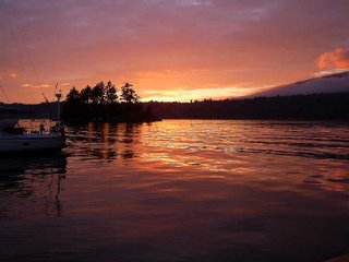
We pulled the prawn traps and were rewarded and we now headed out to Manson’s Landing to harvest oysters and clams. We decided to stay in the gorge at the marina and were witnessed to a beautiful purplish sunset. Awesome.
Too be continued ........

(I will continue on another post as there are pictures I would like to add and only 2-3 seem to work per post. So far I have learned to optimize, compress, upload. I am trying to figure out how to thumbnail the pictures and possibly do a photoalbum to show the many pictures we have. I do accept help if anyone is reading! Unfortunatly I wrote to much and it will not let me download the pictures.)

Friday, March 03, 2006

What is boating about? The sunrises and sunsets, the scenery, the nature, the abundance of fresh seafood, and most importantly the camaraderie with friends. It has been a pleasure over the years that we have
been able to share with our friends the enjoyment of boating.

We departed Port McNeil and headed to Pearse Island Marine Park. Pearse Islands are a group of ten thickly wooded islands. Underwater visibility is up to 25 feet, so you can see the bottom quite easily. We shared this anchorage with only two other boats. As the story in the picture tells, breathtaking. We had a peaceful night and all slept like babies.

The next morning we woke up early to a heavy fog. Heading out we were forced to have the radar in operation. We were going serious salmon fishing. Swanson Island would be our destination, as it is here that Ken's Aunt,Uncle and cousin's do their salmon fishing. We fished from 0715 hrs - 1030 hrs. Eighteen salmon were caught. The secret, play CCR. The fish were biting as long as CCR played loud. The fog began to lift, and to our starboard side a cruise ship began to appear. It was quite a distance away but we had been in the same position earlier in the morning. Thank goodness for radar! Finally I caught a fish. It wasn't real big, about 12 pounds, but hey it was fun. I still had that Halibut to work towards.

At 1145 hrs the fog engulfed us again. We had to head into Fife Sound . Using the radar to help with our safe navigation we creeped slowly towards our destination Pierre's Marina. Located at Scott Cove.

We arrived just in time for pot luck hors oeuvers. This is an opportunity to meet fellow cruisers and possibly learn a thing or two. We were amongst Americans, being the only Canadians. They were all heading back from Alaska. I can't say we learnt too much. A special dice game was played by all the visitors. The winner receives free moorage. We put Bev forward to play for our boat. She won hands down. Off to bed after learning a lot about Rutland Girls!.

The next morning greeted us with bad news. The owners of the marina came knocking on our boat to inform us that an urgent message sent through the Coast Guard had been received, to phone home. Not news anyone wants to hear. Unfortunately Ken's father had suffered a massive heart attack the night before while mowing the lawn. Our vacation would have to be cut short, and we would have to begin heading towards home. Now we were in the middle of paradise but also in the middle of no where!. We could not leave the boat anywhere as all marinas were full, not to mention no means of transportation other than float planes. The boat was turned south. Once in cell range the phone began ringing. Everyone had been trying to find us. The lesson learnt from this was to leave a float plan. We teach it now we needed to practice it!

We still were able to enjoy the wonderful weather on the trip back tothe marina but a cloud of a different sort was above us. A different type of reflection for Ken.


Betty was getting increasingly more itchy and more swollen. Her airways were ok so it was assessed by the Chief and Lieutenant that a trip to Alert Bay Hospital might be in order. It wasn't felt that any eminent danger prevailed so there was no concern to contact emergency personal. We decided to check and see if Alert Bay had a medical facility. It was at this point the Canadian Coast Guard decided that we should not take any chances and dispatched a boat out of Telegraph Cove. Betty's rendition was" It's a great way to have an instant face lift. The Coast Guard fast boat travels at 45 knots. (80 km/hr).

Alert Bay is a fascinating village. It is located on Cormorant Island, amidst splendid scenery and abundant wildlife. This crescent shaped island is situated just off the northeast coast of Vancouver Island, approximately 180 miles by water from the city of Vancouver. Located on the beautiful Inside Passage of British Columbia. Alert Bay offers visitors an incredible look at the 'Namgis First Nation heritage as well as a unique experience in this friendly costal community. We didn't have a chance to visit the Alert Bay Big House and discover the rich past of the KwakwakaÂwakw through their traditional dances. This tradition is something I am truly looking forward to on another visit. We walked the streets along the waterfront. Like so many communities along the coast, many businesses of the past are now closed. I wish I could have witnessed some of the husssel and bussel of the thriving communities. During our brief visit we talked to several fishermen waiting to depart for their salmon season. The allotment of time that the Department of Fisheries and Oceans Canada gives these fishermen is less and less each year. Like the farmers their costs are going up but their profits are plummeting.

We were standing in front of the First Nations cemetery when an Elder from the village stopped. We asked her why some of the totems were beautifully painted while others were left toppled over and uncared for. We learnt a very important fact. The totems are not like headstones in our cemeteries. These totems are erected in memory by the family and tell the history of the person whom they represent. The actual physical bodies (in times gone by) were taken to an outer island where they were suspended in trees. They were then left for nature to take its course. The totems were then erected months or even years later in the honour of the deceased. The totems are to be left as is and allow natures forces to prevail. The idea is that the totems will eventually become part of the earth once again. The circle of life.
The next morning we headed out to do a little fishing. We caught a few Salmon but still not that elusive Halibut. We headed to our next destination Malcolm Island.

Originally established as a Finnish settlement nearly a century ago, the Finnish culture still exists today,on Malcolm Island and is evident in the neat and tidy houses and gardens that surround the town of Sointulta. We wandered up the main street and spoke to a few of the locals. What a wonderful little town. It was at this marina that a neighbouring fisherman gave us a few lessons on what to look for to catch the Halibut. Not to mention how to look at the depth sounder to determine the best anchoring spot. Learning from the pros.

We headed out early the next morning to Port McNeil. We anchored in the harbour waiting to be welcomed into the gas dock, where we would go into town to reprovision and top up our water tanks, and switch crew. We bid our farewells to Betty and John and said hello to Bev and Stan.